
Recent datasets

This dataset summarises benthic surveys of Western Torres, Torres Strait in December 2020 into 3 GIS shapefiles:
(1) The site shapefile describes (a) seagrass presence/absence, (b) species composition, (c) algae cover and (d) benthic macro-invertebrate cover at 542 sites.
(2) The meadow shapefile describes subtidal seagrass communities.
(3) The interpolation shapefile describes variation in subtidal seagrass biomass across the survey area.
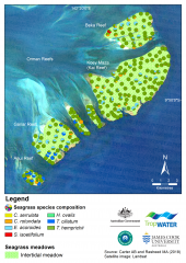
This dataset summarises intertidal benthic surveys of Kai and Gariar Reefs (Orman Reefs, Torres Strait) in November 2018 into 3 GIS shapefiles. (1) The site shapefile describes (a) seagrass presence/absence and (b) species composition at 124 sites. (2) The meadow shapefile describes seagrass communities for the two reef-top meadows. (3) The interpolation shapefile describes variation in seagrass biomass across sites for the two reef-top meadows.
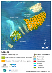
This dataset summarises benthic surveys of seagrass for Dugong and Turtle habitats at Orman Reefs, Torres Strait. The site data describes seagrass coverage estimations at 279 intertidal sites; while the meadow data groups sites into six (6) individual meadows. Data captured includes information on visual estimates for seagrass species, substrate, biomass, diversity, percent cover for benthic macro-invertebrates and algae.
Methods:
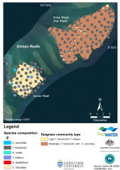
This dataset summarises intertidal benthic surveys of Kai and Gariar Reefs (Orman Reefs, Torres Strait) in September 2019 into 3 GIS shapefiles. (1) The site shapefile describes (a) seagrass presence/absence and (b) species composition at 124 sites. (2) The meadow shapefile describes seagrass communities for the two reef-top meadows. (3) The interpolation shapefile describes variation in seagrass biomass across sites for the two reef-top meadows.
A later version of this dataset exists published 2019-01-18, accessible through the data links on this page.
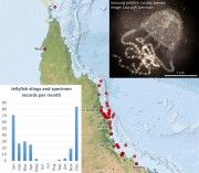
This dataset contains records of sting events and specimen samples of jellyfish (Irukandji) along the north Queensland coast from December 1998 to March 2017. This dataset contains an extract (265 records in CSV format) of the publicly available data contained in the Venomous Jellyfish Database. The full database contains approximately 3000 sting events from around Australia and includes records from sources that have not yet been cleared for release.
This dataset consists of a small CSV file containing the locations, names and country of the Torres Strait villages associated with the Australian and Papua New Guinea Treaty Protected Zone and neighbouring PNG Treaty villages This dataset is intended for the creation of regional maps.
The village locations are not official and were based using satellite imagery to place the village marker on either the centre of the visible village, or the post office location, if that was marked in Google Maps.
This metadata is a brief overview of the National Environmental Science Program Tropical Water Quality (NESP TWQ) Hub.
The aim of the National Environmental Science Programme (NESP) is to assist decision-makers to understand, manage and conserve Australia’s environment by funding world-class biodiversity and climate science.
The National Environmental Science Programme is delivered through six research hubs:
* Clean Air and Urban Landscapes Hub,
* Earth Systems and Climate Change Hub,
* Marine Biodiversity Hub,
This dataset shows larval connectivities between reefs that exceeded, and did not exceed, thermal thresholds for damage during the 2016/2017 Great Barrier Reef bleaching events. The loss of reproductive adult colonies during bleaching events has the implication that coral cover recovery will require the supply of coral larvae from external sources (other reefs).
This generated data set contains summaries (daily, monthly, annual) of the eReefs CSIRO biogeochemistry model v3.1 (https://research.csiro.au/ereefs) outputs at 4km resolution, generated by the AIMS eReefs Platform (https://ereefs.aims.gov.au/ereefs-aims).
This generated data set contains summaries (daily, monthly, annual) of the eReefs CSIRO hydrodynamic model v2.0 (https://research.csiro.au/ereefs) outputs at both 1km and 4km resolution, generated by the AIMS eReefs Platform (https://ereefs.aims.gov.au/ereefs-aims).
This dataset summarises the results of a survey to determine the concentration of trace metals from mine-derived pollution in marine waters and sediments across the Torres Strait during October 2016. Sampling was performed by a CSIRO team between 3 and 16 October 2016 on board the MV Eclipse. Surface water samples were collected from 21 sites using strict sampling protocols that are designed to minimise contamination (USEPA, 1996; Angel et al., 2010b).
METHODS:
This dataset summarises the results of a survey of water quality and suspended solid metal data for ten (10) sites around Saibai and Boigu Islands in the Torres Strait during November 2018. This is the second survey for this project, where the first survey identified the area around Saibai as having elevated metal concentrations compared to other areas of the Torres Strait. This survey was conducted to investigate this finding. Water samples were collected from five sites around Saibai Island and five sites around Boigu Island.
METHODS:
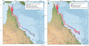
This dataset consists of a shapefile of the reefs, islands, sand banks, cays and rocks of the whole Great Barrier Reef (GBR) including Torres Strait. This dataset is an extension of the mapping in the GBR Marine Park to include Torres Strait. The Torres Strait region was mapped at a scale of 1:50,000 (Lawrey, E. P., Stewart M., 2016) and these new features are referred to as the "Torres Strait Reef and Island Features" dataset.
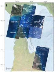
This dataset contains Landsat 5 imagery for selected areas of Queensland, currently Torres Strait and around Lizard Island and Cape Tribulation.
This collection was made as a result of the development of the Torres Strait Features dataset. It includes a number (typically 4 - 8) of selected Landsat images for each scene from the entire Landsat 5 archive. These images were selected for having low cloud cover and clear water. The aim of this collection was to allow investigation of the marine features.
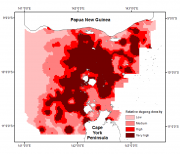
This dataset shows (1) a raster spatial model of the distribution and relative density of dugongs (Dugong dugong) in the Torres Strait region based on an aggregate of 27 years (1987 - 2013) of systematic aerial surveys; and (2) a raster spatial model of the distribution and relative density of marine turtles (green turtles, Chelonia mydas) in the Torres Strait based on an aerial survey conducted in 2013.
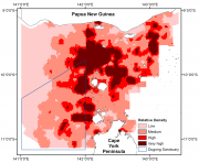
This dataset shows a raster spatial model of the distribution and relative density of dugongs (Dugong dugong) in the Torres Strait region based on an aggregate of 24 years (1987 - 2011) of systematic aerial surveys.

This dataset shows the concentrations of the herbicide glyphosate remaining over time in a simulation flask persistence experiment conducted in 2013.
Glyphosate degradation experiments were carried out in flasks according to the OECD methods for ‘‘simulation tests’’. The tests used natural coastal seawater and were carried out in the incubator shakers under 3 conditions: (1) 25°C in the dark, (2) 31°C in the dark and (3) 25°C in the light. The light levels were ~40 µE on a 12:12 light:dark cycle and the flasks shaken at 100 rpm for up to 330 days.
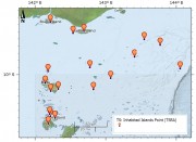
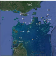
This dataset shows the point location of communities on Torres Strait Islands. There are 18 Islands in the Torres Strait and 19 Communities. St Pauls and Kubin villages are both located on Moa Island. Each point includes an URL attribute pointing to the community pages on the TSRA website. The Island Communities are:
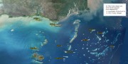
This dataset is a composite of Landsat 5 satellite imagery to produce a cloud free, clear water seamless image of the Torres Strait region. This image includes some of Cape York and PNG, in particular the Fly river. This composite shows clear imagery for marine areas, in particular reefs, larger islands and sand bars.
This image has a resolution of approximately 30 m and a positional accuracy of better than 50 m.
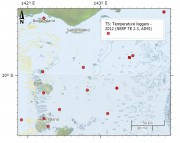
As part of the NERP TE project 2.3 temperature loggers were deployed at 15 sites across Torres Strait to measure the sea temperature. The loggers regularly measure the sea water temperature and record it in their memory. Every year or so the loggers are swapped with new loggers and the recorded data is extracted and recorded in the AIMS Real Time Data Systems database as part of the Australia wide Sea Temperature Observing System.