
Latest environmental research, maps and data for Torres Strait
Recent articles and projects
-
Published on15 August 2016
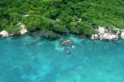 The Land and Sea Management Strategy for Torres Strait (2016-2036) (‘the Strategy’) is a guiding framework for enabling Torres Strait Islander and Aboriginal people to continue to sustainably manage and benefit from their land, sea and cultural resources into the future.
 -
Published on17 June 2015
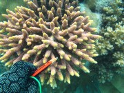 In 2013 and 2014 AIMS undertook a biodiversity survey of coral and fish species on the reefs around 5 islands in Torres Strait. This article shows the coral photo collection that was taken for species identification.
 -
Published on29 April 2015
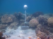
As part of the NERP TE project 2.3 temperature loggers were deployed at 15 sites across the Torres Strait to measure ocean temperature.
-
Published on27 March 2015
No-take marine reserves (NTMRs) are widely advocated for conserving exploited fish stocks and biodiversity.
-
Published on2 December 2014
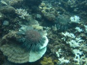
The crown-of-thorns seastar, Acanthaster planci, is a predator of corals and along with cyclones is the major cause of coral mortality on the Great Barrier Reef (GBR) 1 .
Recent datasets

This dataset summarises benthic surveys of Western Torres, Torres Strait in December 2020 into 3 GIS shapefiles:
(1) The site shapefile describes (a) seagrass presence/absence, (b) species composition, (c) algae cover and (d) benthic macro-invertebrate cover at 542 sites.
(2) The meadow shapefile describes subtidal seagrass communities.
(3) The interpolation shapefile describes variation in subtidal seagrass biomass across the survey area.
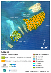
This dataset summarises intertidal benthic surveys of Kai and Gariar Reefs (Orman Reefs, Torres Strait) in November 2018 into 3 GIS shapefiles. (1) The site shapefile describes (a) seagrass presence/absence and (b) species composition at 124 sites. (2) The meadow shapefile describes seagrass communities for the two reef-top meadows. (3) The interpolation shapefile describes variation in seagrass biomass across sites for the two reef-top meadows.
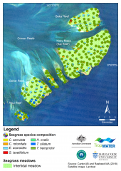
This dataset summarises benthic surveys of seagrass for Dugong and Turtle habitats at Orman Reefs, Torres Strait. The site data describes seagrass coverage estimations at 279 intertidal sites; while the meadow data groups sites into six (6) individual meadows. Data captured includes information on visual estimates for seagrass species, substrate, biomass, diversity, percent cover for benthic macro-invertebrates and algae.
Methods:
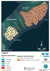
This dataset summarises intertidal benthic surveys of Kai and Gariar Reefs (Orman Reefs, Torres Strait) in September 2019 into 3 GIS shapefiles. (1) The site shapefile describes (a) seagrass presence/absence and (b) species composition at 124 sites. (2) The meadow shapefile describes seagrass communities for the two reef-top meadows. (3) The interpolation shapefile describes variation in seagrass biomass across sites for the two reef-top meadows.
A later version of this dataset exists published 2019-01-18, accessible through the data links on this page.
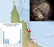
This dataset contains records of sting events and specimen samples of jellyfish (Irukandji) along the north Queensland coast from December 1998 to March 2017. This dataset contains an extract (265 records in CSV format) of the publicly available data contained in the Venomous Jellyfish Database. The full database contains approximately 3000 sting events from around Australia and includes records from sources that have not yet been cleared for release.