
Recent datasets
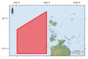
This dataset shows the extent of the dugong sanctuary in the Torres Strait which prohibits the taking of dugong (area, gear and method restrictions).
The dugong sanctuary is a legislative boundary which is outlined in the Torres Strait Fisheries Management Notice No. 65 http://www.comlaw.gov.au/Details/F2007B00345 .
This dataset is for research purposes and is not authoritative. Refer to the legislation for the authoritative definition of the sanctuary.
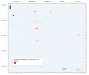
This dataset shows the location and size of the 9 islands, cays and rocks that make up the Warraberalgahl and Porumalgal Indigenous Protected Area (IPA). The IPA is recognised as part of the National Reserve System and was officially declared on the 18/07/2014.
The declared area covers approximately 63 hectares. The following Islands, Cays and Rocks make up the IPA: Atub, Bara, Bini, Babui, Guiya, Maza Guiya, Miggi Maituin, Ugain and Ulu.
This dataset contains a series of high resolution raster Digital Elevation Models (DEM) (1m resolution) around the coastal perimeter of Torres Strait community islands (Badu, Boigu, Dauan, Erub, Hammond, Iama, Mabuiag, Masig, Mer, Moa, Poruma, Saibai, Ugar, Warraber). This dataset was developed for the purpose of mapping levels of coastal inundation under different sea level rise and storm tide scenarios.
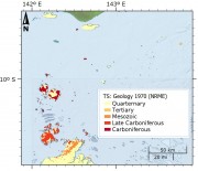
This dataset shows the geology of the Torres Strait region. The polygons in this dataset are a digital representation of the distribution or extent of geological units within the area. Polygons have a range of attributes including unit name, age, lithological description and an abbreviated symbol for use in labelling the polygons. These have been extracted from the Rock Units Table held in the Department of Natural Resources, Mines and Energy Merlin Database.