Dr Eric Lawrey
Background
I completed a Bachelor of Computer Systems Engineering (Honours) from James Cook University (JCU) in 1997 followed by a PhD on modelling improved techniques for wireless communication, also at JCU, in 2001. After university I took up the position of Chief Technical Officer at Code Valley; a startup software engineering company researching a new way of developing software using distributed computing. In 2008 I joined the Australian Insitute of Marine Science (AIMS) as the developer of the eAtlas where I developed its architecture and software. In 2011 I took over as project leader for the eAtlas and now focus on data processing and stakeholder engagement.
Research Interests
My current research interest is in the design and development of the web platform behind the eAtlas that allows knowledge developed through environmental science to be spatially visualised and told as data driven stories. This work includes the development of web techology for delivery of the content, tools for processing environmental data and basemaps for the Great Barrier Reef, its catchments and the Torres Strait.
Author of
This presentation provides an introduction to the concepts needed by content editors of eAtlas.
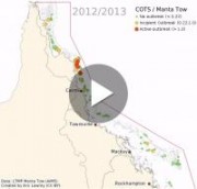
This animation shows the locations of Crown of Thorns Starfish (COTS) outbreaks as measured over the last 30 years.
This animation shows that the COTS outbreaks tend to travel down the coast taking almost 15 years to move from the initiation area north of Cairns to finally reach and dissipate off the reefs offshore from to the Whitsundays.


