NERP TE Project 13.1 - eAtlas (AIMS)
Project summary
The eAtlas is a website, mapping system and set of data visualisation tools for presenting research data in an accessible form that promotes greater use of this information. The eAtlas will serve as the primary data and knowledge repository for all NERP Tropical Ecosystems Hub projects, which focus on the on the Great Barrier Reef, Wet Tropics rainforest and Torres Strait. The eAtlas will capture and record research outcomes and make them available to research-users in a timely, readily accessible manner. It will host meta-data records and provide an enduring repository for raw data. It will also develop and host web visualisations to view information using a simple and intuitive interface. This will assist scientists with data discovery and allow environmental managers to access and investigate research data.
Why this research is needed
Existing research data is often under utilised. Much of it is not readily accessible or else not in a form useful for potential end-users, limiting the ability for science to inform environmental decision making and policy development, or inform the wider community. By providing a data catalogue and repository, the eAtlas will ensure the knowledge gained is safely stored and made accessible, encouraging collaboration and knowledge sharing. In addition, by providing a web-accessible mapping system and a set of data visualisation tools, the eAtlas is able to display a wide variety of spatial data ensuring broad discoverability and easy comprehension.
Research user focus
The eAtlas will deliver timely, rich content that will communicate research outcomes from the NERP TE Hub to government, scientists, community groups and the general public.
Outcomes:
- Maintain existing content on the eAtlas website eatlas.org.au
- Develop new content from NERP TE Hub projects, to ensure projects are documented and the data safely stored.
- Provide a catalogue of NERP TE Hub projects to Research Data Australia (meta-data records).
- Develop a Torres Strait eAtlas for NERP TE Hub research as well as Torres Strait Regional Authority (TSRA) data holdings and priority historical Torres Strait research data.
Resources and tools
Reports, Publications and News
For more information see Project 13.1 'eAtlas for the Great Barrier Reef and Torres Strait' on the NERP Tropical Ecosystems Hub site.
Images
Datasets

The Bright Earth eAtlas Basemap dataset collection is a satellite-derived global map of the world at a 1:1M scale for most of the world and 1:200k scale for Australia. This map was inspired by Natural Earth II (NEII) and NASA's Blue Marble Next Generation (BMNG) imagery.
Its aim was to provide a basemap similar to NEII but with a higher resolution (~10x).

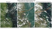
This collection is a record of MODIS satellite imagery before, during and after severe cyclone Yasi in February 2011. This image series highlights the damage the cyclone makes to the rainforest areas around mission beach and the turbulence created off shore by the cyclone on the 5th February (2.5 days after the cyclone). It corresponds to the images and maps from the "Cyclone Yasi satellite image maps - before and after" article in the eAtlas. Use this dataset if you wish to recreate these maps.
This layer shows a 500m resolution image of the world derived from the Blue Marble Next Generation April 2004 image (86400x43200 pixels).
As the image was derived from MODIS satellite imagery during Autumn in the Northern Hemisphere the high latitude countries (Russia, Canada, etc) are covered in snow.

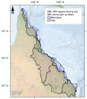
This dataset corresponds to the Natural Resource Management (NRM) Regions corresponding to river catchments neighbouring the Great Barrier Reef Marine Park. The original aim of this dataset was to show river basins that flow into the Great Barrier Reef (GBR) Marine Park, grouping them by their NRM region. The NRM region boundaries already mostly correspond to a grouping of river basin boundaries and so this regrouping of river basins was unnecessary.

This dataset corresponds to a reformatting of the SRTM30_PLUS digital elevation dataset from 33 NetCDF files into a single GeoTiff for use in GIS applications. No other modifications to the data were done. The rest of this metadata describes the original SRTM30_PLUS dataset itself.
Note: The SRTM15_plus dataset is a similar more recent, higher resolution bathymetry dataset https://topex.ucsd.edu/WWW_html/srtm15_plus.html.


